July 11, 18 at 6:30
August 6, 21
October 4
Greenwich Village
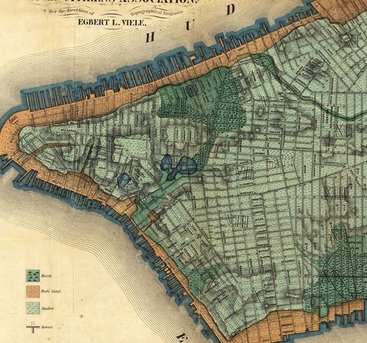
Before NYC became concrete and asphalt, the island was covered by rivers, streams and marshes. Greenwich Village’s Minetta Brook is one such watercourse and still makes its presence known in the basements of the structures built on top of it; some are still visible if you know where to look.
Join urban explorer Steve Duncan of Undercity.org as he shows us the Minetta’s 1.5 mile buried path and explains the waterway functioning both today and in the past. He’ll point out the secret code on manhole covers, tell you what their placement means, and how different engravings indicate what lies beneath the city. On the walk, you can peer into ventilation holes and manhole covers to get a glimpse of the underground waterways. Afterward, you may never walk the city’s streets again without wondering what lies beneath.